

Lower Wisconsin State Riverway
(LWSR2) Spring Green to Muscoda, Wisconsin Trail Guide
Trail Facts
| Distance: | 22.5 miles |
| Skill Level: | Easy |
| Whitewater: | Flat |
| Approx. Paddle Time: | 11+ hours |
| Elevation Drop: | 40 feet |
| Average Gradient: | 1.8 fpm |
Synopsis
Trail Review
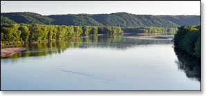
This segment of the Lower Wisconsin Riverway is less traveled than the previous. The river wanders past a wonderfully varied landscape of forests, high bluffs, rolling hills and occasional sandy barrens. Islands seem to be more numerous, and larger, sharing the river with dozens sandbars (in normal flows).
For most of this segment, dense mesic forest covers the riverbanks. Sugar Maples are common, along with: ash, beech, hickory and basswood. Steep hills and tall bluffs overlook the river in the middle and latter stages where oak, cherry, maple, red cedar and occasional stands of tall white pines cover the slopes.
There are several areas of moist bottomland forests where tall grasses and sedges provide a rich understory beneath a canopy of river birch, black willow and various swamp hardwoods.
The riverbanks tend to be less sandy, except for one stretch near the Buena Vista Landing at Gotham, where you'll find high sandy banks and thickets along the shoreline, mostly on the north bank - open savannah extends inland from the river along the opposite, south bank.
Birdlife continues to be very abundant along with other wildlife including white-tailed deer, and the occasional turtle.
Camping
Sandbars continue to be common during low to moderate flows providing numerous, fun opportunities for camping.
From Peck's Landing at Spring Green, Devil's Lake State Park is about 33 miles driving distance to the northeast. The second most visited State Park in Wisconsin, Devil's Lake features a 360-acre lake surrounded by 500-foot bluffs. Recreational opportunities abound, including: miles of scenic hiking trails and overlooks (including a segment of the Ice Trail); rock climbing; sailing, canoeing and kayaking with boat rentals available; several huge shaded picnic areas; a nature center and two historic concession buildings. There are 3 family campgrounds with a total of 423 sites, and 9 group campsite that accommodate a total of 240 people. 364 sites are reservable.
Check out the excellent Devils Lake State Park Visitor Guide website for more information on visiting the park.
Governor Dodge State Park is just 11.6 miles south of Peck's Landing at Spring Green on Highway 23. The park offers: forty miles of hiking trails; eight miles of mountain bike trails; twenty-two miles of horse trails; eight picnic areas; and a pair of lakes with swimming beaches, and boat launches for canoeing and kayaking. There are two family campgrounds at Governor Dodge; Cox Hollow and Twin Valley, with a total of 269 campsites. Other types of camping include: six backpack sites; eight group sites (15 - 40 people per site); and eleven horse campsites.
Densely wooded Tower Hill State Park sits next to the river near the beginning of this segment and offers a small family campground with easy river access for canoe camping. Although this park doesn't exude the same “fun energy level” as Devil's Lake or Governor Dodge, it does offer: scenic bluff trails, eleven shady campsites, a picnic area, restrooms, water, and a very unique historical site that is well worth a visit. Camping is on a first-come, first-served basis.
The beautiful Blackhawk Lake Recreation Area is just a few miles west of Governor Dodge State Park. The park features a beautiful lake surrounded by rolling hills. Activities and amenities include: camping, hiking, boating and fishing. This is an excellent campground for RV camping. There are also plenty of shaded sites for tent camping, and several lakeside cabins. There are a total of 150 campsites. 135 are reservable; call 608.623.2707 to reserve a site, or visit the website and fill out the online reservation form.
Season
The river is usually navigable throughout spring, summer, and fall. It can be scrappy in places during periods of little rainfall in summer and fall. Paddlers should avoid the river in early spring, or whenever water levels are especially high.
River Level Information
River Gauge Location: State Hwy 80 Bridge at Muscoda
USGS Website: USGS Gauge @ Muscoda, WI
Phone Contact for River Info: Contact local shuttle service / livery (see Local Business Directory page).
Always check the local weather forecast before paddling on the LWSR. Also, even if the local forecast calls for sunny conditions, talk to a local outfitter about possible river surges before embarking on an overnight trip! Although it may be sunny in the LWSR, any kind of heavy rainfall upriver can result in an unexpected rise in river levels. Although this set of conditions doesn't happen very often, it occasionally does, and is something to be aware of.
Suggested River Levels
| Below 4,000 cfs |
Very shallow riverway, many large sandbars. You may have to step out and push several times. Excellent conditions for sandbar camping! |
| 4,000 cfs to 10,000 cfs |
Normal summer conditions, many medium to large-sized sandbars. Shallow riverway at low end of this range - occasionally, you may have to step out and push. Excellent conditions for sandbar camping! |
| 10,000 cfs to 14,000 cfs |
Above normal flow conditions, noticeable undercurrents developing, especially in lee of sandbars and islands. Sandbars are smaller and fewer in number at high end of this range. Usually acceptable conditions for sandbar camping. |
| 14,000 cfs to 17,000 cfs |
High flow conditions. Undercurrents above 4 mph develop, especially in lee of sandbars. Sandbars are few in number. Sandbar camping not recommended in this range. |
| 17,000 cfs to 20,000 cfs |
High flow conditions with deceptively powerful undercurrents developing. Overnight camping on sandbars and beaches not recommended! Can be a fun day trip however, many small channels open up in lower reaches of the LWSR - be careful of strainers in narrow confines. |
| Above 20,000 cfs |
Paddling not recommended! |