

Lower Wisconsin State Riverway
(LWSR4) Woodman to Bridgeport, Wisconsin Trail Guide
Trail Facts
| Distance: | 12.9 miles |
| Skill Level: | Easy |
| Whitewater: | Flat |
| Approx. Paddle Time: | 5-6 hours |
| Elevation Drop: | 23 feet |
| Average Gradient: | 1.8 fpm |
Synopsis
Trail Review
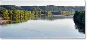
Paddlers will find a beautiful, peaceful float in the final reach of the Wisconsin River. There is often more quiet and solitude in this final segment than any of the previous. Fewer roads border the riverway and even there is very little development. Many longtime paddlers of the Lower Wisconsin believe the river only becomes more beautiful the closer you come to the Mississippi River confluence. If you paddle this segment you may agree!
A series of large wooded islands occupy the river as you paddle west from the scenic area surrounding Woodman Boat Landing. Steep ridges and rolling hills border the river along the south bank in the initial stretch. As the river flows away from the hills you will glide past lush bottomland forest and dense undergrowth. Numerous sloughs branch off with a large number of creeks adding their flow to the river.
Steep ridges once again border the river along the south bank as the Wisconsin runs past the Millville Boat Landing. Several large wooded islands fork the channel. Continuing west, the river angles away from the southern bluffs and eventually pushes up against a series of low ridges and high banks along the north shore.
The river flows around a densely packed series of long, narrow, wooded islands as it approaches the Highway 18 Landing, the final access before the Mississippi River confluence.
Wildlife continues to be abundant. Besides the numerous species of birds, you will likely see beaver, white-tailed deer, turtles, and the occasional otter, especially during the early morning and late afternoon hours.
Wyalusing State Park offers a unique river trail through the Mississippi River bottomlands. You'll actually paddle through part of this trail if you take out at the park. The trail is an interesting and up close way to experience a portion of the northern Mississippi River ecosystem.
Camping
Sandbars continue to be common during low to moderate flows providing numerous, fun opportunities for camping.
“At Wyalusing State Park, camp 500 feet above the confluence of the Wisconsin and Mississippi rivers. One of Wisconsin's oldest state parks, Wyalusing features family and group camps, hiking trails, a canoe trail, Native American burial mounds, bird watching, fishing, boating, bicycling and picnicking near several scenic overlooks of the river valleys below.” _WI DNR
The beautiful Nelson Dewey State Park is just a few miles south of Wyalusing State Park and features a 500-foot bluff overlooking the Mississippi River with gorgeous panoramic views. The park offers scenic hiking trails, three picnic areas, and a family campground with 45 sites and three group camps that can acommodate up to 40 people each. All sites are reserveable.
Season
The river is usually navigable throughout spring, summer, and fall. It can be scrappy in places during periods of little rainfall in summer and fall. Paddlers should avoid the river in early spring, or whenever water levels are especially high.
River Level Information
River Gauge Location: State Hwy 80 Bridge at Muscoda
USGS Website: USGS Gauge @ Muscoda, WI
Phone Contact for River Info: Contact local shuttle service / livery (see Local Business Directory page).
Always check the local weather forecast before paddling on the LWSR. Also, even if the local forecast calls for sunny conditions, talk to a local outfitter about possible river surges before embarking on an overnight trip! Although it may be sunny in the LWSR, any kind of heavy rainfall upriver can result in an unexpected rise in river levels. Although this set of conditions doesn't happen very often, it occasionally does, and is something to be aware of.
Suggested River Levels
| Below 4,000 cfs |
Very shallow riverway, many large sandbars. You may have to step out and push several times. Excellent conditions for sandbar camping! |
| 4,000 cfs to 10,000 cfs |
Normal summer conditions, many medium to large-sized sandbars. Shallow riverway at low end of this range - occasionally, you may have to step out and push. Excellent conditions for sandbar camping! |
| 10,000 cfs to 14,000 cfs |
Above normal flow conditions, noticeable undercurrents developing, especially in lee of sandbars and islands. Sandbars are smaller and fewer in number at high end of this range. Usually acceptable conditions for sandbar camping. |
| 14,000 cfs to 17,000 cfs |
High flow conditions. Undercurrents above 4 mph develop, especially in lee of sandbars. Sandbars are few in number. Sandbar camping not recommended in this range. |
| 17,000 cfs to 20,000 cfs |
High flow conditions with deceptively powerful undercurrents developing. Overnight camping on sandbars and beaches not recommended! Can be a fun day trip however, many small channels open up in lower reaches of the LWSR - be careful of strainers in narrow confines. |
| Above 20,000 cfs |
Paddling not recommended! |