

Amnicon Falls State Park
Waterfalls, Wisconsin Trail Guide
Trail Facts
| Distance: | 0.8 miles |
| Exertion/Intensity: | Very easy |
| Terrain: | Mostly flat |
| Elevation Gain: | > 100 feet |
| Trail Surface: | Varies |
| Rocks & Roots: | Occasional |
Trail Review
Synopsis
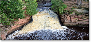
Scenic Amnicon Falls State Park covers eight hundred and fifty acres and features four named waterfalls on the Amnicon River: Upper, Lower, Snake Pit, and Now & Then Falls. The park also features several unnamed waterfalls and a long stretch of roaring rapids. The close proximity of the waterfalls and rapids to each other combined with a large number of scenic viewing points make this one of the most accessible waterfall areas in the Midwest.
Upper Falls and Lower Falls are the park's main attractions. Both occur where the river's main channel rumbles over a pair of twenty-foot high cascades, one after the other in close succession. Lower Falls - the second or lower of the two - ends in a scenic sandstone canyon surrounded by tall red and white pines.
The more intimate Snake Pit Falls occurs where a small branch forks from the Amnicon River and flows over two narrow ledges into a narrow rocky gorge. The gorge runs for less than fifty yards before it opens into the Amnicon's main channel below Lower Falls. Snake Pit Falls are the highest waterfall in the park but receive quite a bit less flow than Upper and Lower Falls.
The fourth and smallest named falls in the park are Now and Then Falls. This tiny waterfall is formed by another short, small branch of the Amnicon River that only flows when river levels are high. There is a miniature canyon about a hundred yards below Now and Then that can be interesting to walk through.
When you look at the park map you will see a couple of designated trails along the river and on the island. However, there is very little undergrowth beneath the wide canopies of the tall pines which makes it easy to stray from the 'designated' trails and wander from one scenic spot to the next.
Horton Bridge
A uniquely designed, fifty-five foot bridge spans the river just above Lower Falls. Interestingly enough, the bridge originally had no roof, and was built where a nearby county highway crossed the river. The bridge was moved here in 1930, had a roof installed in 1939, and was once the site of parties and social events thrown by the locals.
The bridge was designed by inventor Charles Horton who was a brief resident of Superior in 1897 and 1898 before settling in La Crosse, WI. His unique bridge design called for the use of arched support beams as well as hook clips instead of rivets and bolts. He claimed this made the bridge cheaper, stronger and easier to build. This style of bridge became known as a "Horton" or "Bowstring" bridge. Only six bridges of this type still exist today, the other five are located in the Van Loon Wildlife Area near La Crosse.
Day Use Area
Amnicon Falls State Park has one of the most scenic, day-use picnic areas in Wisconsin. A large number of cool, shady picnic tables with bbq grills are scattered along the river beneath tall red and white pines, many alongside the rapids above Upper Falls. This is an excellent and fun place for families to spend an afternoon relaxing and exploring. While the falls here may not be as dramatic as those located at nearby Copper Falls and Pattison State Parks, a visit here is still highly recommended. Consider camping here or at Copper Falls and enjoying a weekend tour of all three waterfall parks. Hike the falls at one of the other State Parks in the morning, then spend the afternoon here, where you can eat lunch and relax at one of the many gorgeous picnic spots.
More Information
Website: Amnicon Falls State Park
Phone Contact: 715.398.3000
Trail Access Fee: Yes, WDNR Vehicle Admission Sticker required. Daily or annual.