

Montreal River
(MO1) Montreal River Canyon, Wisconsin Trail Guide
Trail Facts
| Distance: | 3.2 miles |
| Skill Level: | Advanced |
| Whitewater: | Class II-IV |
| Approx. Paddle Time: | 2+ hours |
| Elevation Drop: | 168 feet |
| Average Gradient: | 52.5 fpm |
Synopsis
Trail Review
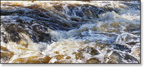
Many consider this as one of the premier, advanced whitewater runs in the Upper Midwest. The canyon run features long continuous stretches of wavy class II to III rapids and ledges with numerous holes and excellent play spots. At high water levels, a few of the drops and long pitches rate class IV forming large haystacks and wave trains.
Most of the three-mile stretch is through the incredibly scenic Montreal River Canyon where sheer conglomerate walls reach heights of up to 300 feet above the river. The rugged scenery in the canyon is among the best in Wisconsin. Pine, spruce and hemlock often cover the steep slopes and cliffs along with stands of birch and aspen.
While the gorge has spectacular scenery, it also creates a somewhat precarious situation, once you are committed to making the run you will not be able to change your mind. It is very, very difficult to get out of the canyon on foot after the first quarter mile. Jim Rada, author of 'Northwoods Whitewater', basically states that; in the interest of safety, "it's good to have a group mentality here" when attempting this run. Good advice.
This run should only be attempted by advanced and expert whitewater paddlers.
The Montreal River Canyon sits between two of the tallest waterfalls in the upper midwest. The first, Saxon Falls, is located just above the put-in and has a total drop of 90 feet. Unfortunately, the falls normally run at a trickle, only providing a full cascade during a dam release from the Saxon Falls Dam a short distance upstream. The second waterfall is Superior Falls, located a few hundred yards north (downstream) of the Highway 122 Landing. Superior Falls are 110 feet high over several drops. There is a scenic overlook that offers a partial view of the falls off Highway 122 on the Michigan side.
This segment of the Montreal West Branch forms part of the upper northern border between Wisconsin and the Upper Michigan Peninsula. The Montreal River is one of the few rivers in the US that flows north, emptying into Lake Superior.
The Montreal West Branch is used for Hydro-electric power which means water levels fluctuate greatly! You must call the hotline (see below) before making the run to find out when the next release is (if there is one!). During a dam release, water levels rise rapidly without warning and will change the character of the river dramatically. Always wear proper safety equipment, don't paddle alone, and be sure to let a friend or relative know where you are just in case.
Camping
Wisconsin State Park Campgrounds
Copper Falls State Park is about a 35 minute drive from the intersection of County B and Highway 122. The family campground offers 56 secluded campsites, and a group camp for tent camping (up to 40 people). This is the most scenic gorge and waterfall area in Wisconsin and the Doughboys Trail is featured in this guide.
“Ancient lava flows, deep gorges and spectacular waterfalls make Copper Falls one of Wisconsin's most scenic parks. Log buildings built by the Civilian Conservation Corps in the 1930s add to the park's charm. There is plenty to do; hiking, bicycling, picnicking, fishing and swimming. The North Country National Scenic Trail passes through Copper Falls State Park.”
_source: Wisconsin DNR.
Season
The water levels are controlled by release from the Saxon Falls Dam. Excel Energy Power Company has set up a hotline with a recorded message about current conditions at 715.893.2213.
Opinions vary when it comes to good water levels for enjoyable paddling. For experienced paddlers, the best action occurs: during a dam release; during the spring meltoff; and/or occasionally in late fall. The river is normally too shallow to navigate in summer and fall.
Exercise common sense, and know your limitations!
River Level Information
Phone Contact for Info: Excel Energy hotline (recording); 715.893.2213
USGS Website: There is no USGS River Gauge for this segment.