

Pike River
(PK1) Amberg to Yellow Bridge Landing, Wisconsin Trail Guide
Trail Facts
| Distance: | 9.4 miles |
| Skill Level: | Intermediate |
| Whitewater: | Class II (III) |
| Approx. Paddle Time: | 4 hours |
| Elevation Drop: | 90 feet |
| Average Gradient: | 9.8 fpm |
Synopsis
Trail Review
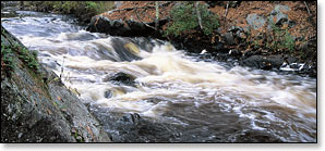
Though not nearly as popular as the nearby Peshtigo and Wolf Rivers, the Pike River below Amberg is just as scenic, if a bit less dramatic. Numerous rock formations and stands of mixed pines and hardwoods dominate the river shoreline. The Pike is protected by the Wisconsin Wild Rivers Act of 1965, which has greatly restricted any kind of development along the river.
Paddling This Segment
The first six miles from the Highway 141 bridge in Amberg down to Highway K is mostly flatwater with periodic riffles and class I rapids. The exception is Bull Falls, a fun class II located about a half mile below Highway 141 in a gorgeous dells setting (Bull Falls should be portaged by less-experienced paddlers).
The river, and the scenery, become more rugged below County K where canoers and kayakers will begin to encounter more frequent whitewater including a pair of solid class II's. First is Scrounge Canyon. Located in a scenic, narrow dells the rapids feature fun waves and numerous eddies. You can bomb the 'Canyon', or take your time and play for awhile. Scrounge Canyon is the best and most scenic rapids in this segment. The second class II is at Horseshoe Falls. Another fun drop that is much shorter. Both should be scouted. Take-out at the Yellow Bridge Landing.
In anglers terms, the Pike River is a ‘freestone’ river with a reputation as an excellent trout stream. However, the river is not stocked.
Whitewater Paddler's Tip
Experienced whitewater canoers and kayakers should consider the class III short-run (0.2 mile) of Yellow Bridge Falls and Rapids. Put-in at the Yellow Bridge Landing (see map, mile 4.8) on Pike River Road and takeout at the Pike River Road Access just south of the Barker Road intersection. The falls and rapids are bony and dangerous in lower flows, but when river levels are medium to high runnable (see chart below), the first fifty yards below the bridge provide an awesome whitewater experience!
Other fun area attractions include Dave's Falls County Park in Amberg and the Pike River/4 Seasons Club Loop Bicycle Trail. Anglers will find the river to be an excellent trout stream.
Camping
Marinette County Parks Campgrounds
There are a pair of beautiful County Park Campgrounds on the Peshtigo River that are within a 40-minute drive of Amberg: Goodman Park (P3 & P4) and McClintock Park (P4). Both have scenic day-use areas with trails and footbridges over the Peshtigo, a well-known whitewater river. 15 sites at Goodman Park are reservable.
Wisconsin State Park/Forest Campgrounds
Old Veteran's Lake,
Peshtigo River SF RESERVE A CAMPSITE
Governor Thompson
State Park
Governor Thompson State Park and the Peshtigo River State Forest are both less than a 45-minute drive from Amberg. Governor Thompson State Park has 2,800 acres of forest and lakes, and six miles of undeveloped shoreline on the Peshtigo River's Caldron Falls Flowage. The park also features over 16 miles of hiking trails and a family campground with 106 campsites in a scenic wooded setting. 103 campsites are reservable.
The Peshtigo River State Forest is Wisconsin’s newest state forest and features over 12,000 acres of beautiful forests and scenic waters. The Old Veteran's Lake family campground sits in an hardwood forest next to a small lake and offers sixteen campsites. Twelve are reservable during the summer.
Season
The Pike has a deeper streambed than most small rivers, which makes it more consistently navigable. However, the rapids below County K can be too shallow to navigate when river levels are low.
River Level Information
River Gauge Location: USGS Gauge at Amberg, County Highway V Bridge
Suggested Minimum Level: 2.9 feet
USGS Gauge Station: USGS Gauge @ Amberg
The river gauge referenced below is located one mile upstream from the Highway 141 put-in and should provide an accurate indication of current conditions in this reach.
Suggested River Levels:
| Bank Full Stage is 4.5 feet. (Source: National Weather Service) | |
| Below 2.5 feet | Paddling not recommended. |
| 2.5 feet to 2.9 feet |
Low runnable flow. Scenic river trip for novice paddlers from Highway 141 to County K Bridge. Likely have to portage Bull Falls. Paddling not recommended below County K Bridge. |
| 2.9 feet to 3.5 feet |
Low runnable flow. Scenic whitewater river trip for novice paddlers from Highway 141 to Yellow Bridge Landing. Yellow Bridge Falls are barely runnable at low end of this range. |
| 3.5 feet to 4.1 feet |
Medium runnable flow. Scenic whitewater river trip for novice paddlers from Highway 141 to Yellow Bridge Landing. Yellow Bridge Falls (class 3) developing fun waves at high end of this range. |
| 4.1 feet to 4.6 feet |
High runnable flow. Challenging whitewater river trip for novice paddlers from Highway 141 to Yellow Bridge Landing. Bull Falls are approaching class 3. Yellow Bridge Falls (class 3) producing pushy waves at high end of this range. |
| 4.6 feet to 5.0 feet |
High runnable flow. Novice paddlers should avoid the river. Pushy waves developing in several rapids. Waves at Yellow Bridge Falls (class 3-4) may overpower intermediates. |
| Above 5.0 feet | Rare, unusually high flows. Paddling not recommended. |