

Red River
(R1) Weed Dam Powerhouse to Zeimer's Falls, Wisconsin Trail Guide
Trail Facts
| Distance: | 2.2 miles |
| Skill Level: | Intermediate |
| Whitewater: | Class III-IV |
| Approx. Paddle Time: | 1-2 hours |
| Elevation Drop: | 32 cfs |
| Average Gradient: | 14.5 fpm |
Synopsis
Trail Review
This short stretch of the Red River serves up a fun, intermediate whitewater run that often has a reliable flow when other rivers are running low. Water levels are mainly dependent on release from the Weed Dam Powerhouse which is located near the put-in for this segment.
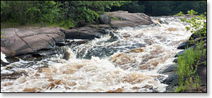
Intermediate whitewater kayakers and canoers will find several pitches of rapids that offer excellent play opportunities to practice and perfect their play-boat skills. The most consistent play-spots are at Zeimer's Falls (Class III) and Second Drop Rapids (class I-II). Both feature nice surf waves! The most challenging rapids are at Monastery Falls, a narrow rocky chute that rates class III-IV.
The river flows through a scenic strip of woodlands surrounded by farmlands. A variety of hardwoods including maple, oak, ash, and cottonwoods canopy the river banks. When you're on the river all you'll see is the forest, you usually won't notice the pastures and fields that are less than a hundred yards away.
Camping
Chequamegon-Nicolet National Forest Campgrounds
The Chequamegon-Nicolet National Forest has an excellent family campground about a 40-minute drive north of the Red River. Beautiful and popular Boulder Lake Campground has 89 individual sites and 10 group sites; many of which are reservable. Campground facilities include a shady picnic area, swimming beach, hiking trails, boat ramp, flush toilets, showers, water and an RV dumping station. Boulder Lake is 362 acres in size and is noted for walleye, pike, panfish and bass fishing.
The Boulder Lake Campground is less than two miles from the Wolf River near Markton.
Season
Weed Dam Releases: There are two power dams on the Red River at Gresham that effect water flow for this segment; the ‘Upper Dam’ below Upper Red Lake, and the ‘Weed Dam’ below Lower Red Lake. Since 2004, both dams have operated on a ‘run-of-river’ basis; which means both dams release with the natural seasonal river flow, while (in this case) maintaining a consistent water level in both lakes/reservois.
The USGS Gauge on the Red River is located approximately 6 miles upstream from Upper Dam and approximately 8 miles above Weed Dam. So while readings from this Gauge will usually do a good job of indicating streamflow for the segment R1, river levels in R1 may be lower than indicated during dry periods/seasons when releases are somewhat limited to keep the lakes/reservoirs at desirable levels.
A good on-site, visual way to determine the height of the river is to look at the base of the Weed Dam Powerhouse wall where it meets the water, a large gap means low water levels, while no gap means the river is high and the rapids downstream will be fast and challenging. A horn will sound just before a release.
If you decide to paddle during low water, pay attention to the river level as it can change in a hurry after a dam release. When water levels are low, the river is still navigable but the rapids are far less challenging and can be scrappy in several places. When water levels are high, the rapids provide fun class II to IV, small-river wave action.
River Level Information
Weed Dam Releases
The USGS Gage referenced below is located approximately 6 miles upstream from Upper Dam and approximately 8 miles above Weed Dam. So while readings from this gage will usually do a good job of indicating streamflow for the segment R1, waterflows in R1 may be lower than indicated during dry periods when releases are somewhat limited to keep the lakes/reservoirs at desirable levels.
River Gauge Location: USGS Gauge at Morgan Rd near Morgan, WI
Suggested Minimum Level: 100 cfs
USGS Gauge Station: 04077630
Suggested River Levels:
| Below 80 cfs | Paddling not recommended. |
| 80 cfs to 150 cfs |
Low runnable flow. Some rapids will be scrappy boulder gardens. You may have to portage Monastery Falls at low end of this range. |
| 150 cfs to 250 cfs |
Low to medium runnable flow. This is a good range for intermediates looking to develop their skills on several of the rapids and waves. |
| 250 cfs to 500 cfs |
Medium runnable flow. Monastery Falls (class III+) and Zeimers Falls (class III) are both producing fun waves. |
| 500 cfs to 800 cfs |
High runnable flow. Monastery Falls producing class IV waves. The main drop at Zeimers Falls is 'pushy' class III+. |
| 800 cfs to 1,000 cfs |
Advanced-level paddlers only. Big, powerful waves at Monastery and Zeimers, exercise caution! |
| Above 1,000 cfs | Rare, unusually high flows. Paddling not recommended. |