

Synopsis
Paddling the St Croix River
The St Croix National Scenic Riverway was created when congress passed the National Wild and Scenic Rivers Act of 1968. This act greatly restricted development along the upper St Croix River in order to protect and preserve the river’s wild and scenic character. The original act only covered the upper St Croix region. The lower region was added in 1972. Today, 155 miles of the river are protected under management of the National Park Service, the Minnesota DNR and the Wisconsin DNR.
The headwaters of the St Croix River are located at the south end of Upper St Croix Lake in Wisconsin. From there the river flows for 169 miles before joining the Mississippi River near Prescott, Wisconsin. The final 125 miles serves as the border between Wisconsin and Minnesota.
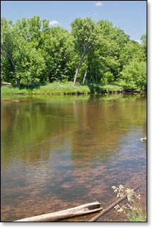
This guide covers the upper St Croix River from Gordon Dam to Highway 70, one of the most popular and scenic paddling destinations in the Upper Midwest. Visitors will find a wild and beautiful river surrounded by a dense, northern mixed hardwood forest. Maple, birch, oak, aspen and basswood are common along with frequent stands of pine and spruce.
The surrounding forests and marshlands are home to a wide variety of wildlife. Eagle and osprey are occasionally spotted, perched atop tall pines scanning the river for their next meal. Other birdlife includes warblers (in spring), waterthrush, finches, woodland duck, and swans (near Gordon Park). Common mammals include beaver, otter, black bear, and whitetail deer. When camping at one of the canoe campsites, you may hear timber wolves yapping and howling during the night.
There is plenty of solitude for paddlers. You can enjoy a quiet afternoon trip or a fun multi-day excursion due to the large number of canoe campsites.
Paddling the Upper St Croix
The first eight miles of the St Croix River meander through marsh and bog until entering the St Croix Flowage near Gordon Wisconsin. Gordon Dam, at the west end of the flowage, marks the beginning of the St Croix National Scenic Riverway and its 155 miles of protected waters. From Gordon Dam, the narrow upper reaches of the St Croix (SC1 and SC2) are often shallow flatwater with occasional short, rocky rapids. Big Fish Trap Rapids, a challenging class II is located in SC1 and is one of the most difficult rapids of the entire river. Below the Namekagon River confluence, the St Croix becomes wider and deeper.
From Riverside Landing to Highway 70 Landing (Segments SC3, SC4, SC5), the river passes through a region known as 'The Marshland'. In this region, “land islands” of upland forest are surrounded by huge tracts of densely wooded marshlands where a lush and vibrant forest filled with wildlife surrounds the river. This is a unique and beautiful area with a wonderful variety of scenery. Paddlers will also find a large number of wooded islands with narrow channels where hardwoods often canopy the riverbanks. Sandstone cliffs and steep sandy banks are present where the river passes rolling hills.
There are no rapids in the 28 miles from Riverside to Norway Point (SC3 and SC4). This is a wonderfully scenic stretch for quietwater enthusiasts. There are a total of 9 canoe campsites in these two segments with river access to multiple family campgrounds in Minnesota’s beautiful St Croix State Park in SC4.
Segment SC5 below Nelson’s Landing is especially popular for paddlers who enjoy paddling through riffles, low-hazard rapids and wild back-country. This segment features the Kettle River Slough, the rugged right channel where the river forks around several large islands. Although the slough can be unnavigable in low river levels; in medium to high water conditions the right fork offers gorgeous scenery and fun, challenging whitewater for novice paddlers. There are 19 canoe campsites in this segment, and river access to St Croix State Park (MN).
Whitewater on the St Croix
The most significant rapids occur in segments SC1, SC2 and SC5. SC1 has numerous pitches of rocky class I and II rapids between Gordon Dam and Louise Park Landing. SC2 features Big Fish Trap Rapids, a strong class II that is some of the most difficult whitewater on the St Croix; the rapids begin about a mile above the CCC Bridge Landing and extend for more than half a mile. Big Fish Trap Rapids will rate class III in high water conditions. SC5 has a long succession of class I and class II rapids over a four-mile stretch beginning near Nelson's Landing. The rapids in the Kettle River Slough are class I to II in medium flows but can produce challenging, class II+ wavetrains during high flows. Watch for the channel-wide ledge on river-right at the forks confluence.The rest of the upper St Croix is mostly flatwater with occasional, shallow riffles and low-hazard rapids.
Canoe/Kayak Camping
Canoe and kayak camping is a great way to explore and experience the St Croix River. The St Croix National Scenic Riverway (National Park Service) has twenty-two individual and twenty-one group campsites for canoe camping on the Upper St Croix River, between Gordon Dam Landing and Highway 70 Landing. Individual sites accommodate up to three tents and/or eight people, while the group sites hold up to six tents and/or sixteen people. There are no fees for accessing, camping, or parking in any of the National Scenic Riverway areas. There is a three night limit of stay. All sites are on a first-come, first-served basis. No glass beverage containers are allowed on the riverway!
Douglas County Park Campgrounds
The beautiful and popular Gordon Dam County Park (SC1) features a family campground with 33 shaded campsites, 12 with electric hookup. This is a well-maintained and scenic county park, one of the best in northern Wisconsin. Most of the park's campers and visitors are here to fish the St Croix Flowage. The park offers a canoe landing below the dam for St Croix River access and a boat landing above the dam for the Flowage. Amenities include water, toilets and a fish-cleaning station. All sites are available on a first-come, first-served basis. Online reservations are not available at this time.
Wisconsin State Forest Campgrounds
The entrance to Governor Knowles State Forest is about 150 yards east of the Highway 70 Landing (SC5), on Highway 70. The St Croix Family Campground has 30 rustic sites, none are reservable. The 34,000 acre park borders the St Croix Riverway in Wisconsin and features more than 78 miles of scenic hiking and equestrian trails.
Minnesota State Park Campgrounds
Minnesota's St Croix State Park is about a 16 minute drive west from Thayer’s Landing (SC3, SC4) on Minnesota Highway 48. This is Minnesota's largest state park and features more than 200 miles of hiking, biking and horse trails. Four landings in Segments SC4 and SC5 provide direct access to the park from the St Croix River: Little Yellowbanks, the Main Canoe Landing, Sand Creek Landing and Head of the Rapids Landing.
The St Croix State Park has three campgrounds with a total of: 211 drive-in sites, 2 backpack sites, 4 walk-in sites and, 7 canoe/kayak campsites on the St Croix River. Firewood is available year-round.
There is a concession building that "offers canoe rentals, shuttle service and sells groceries, ice, camping supplies and convenience items as well as Nature Store items that include t-shirts, caps, gifts. Open daily Memorial Day through Labor Day and on weekends only from May 1 to Memorial Day and Labor Day through Oct. 1."
The Visitor Center lodge "is located in the vicinity of the campgrounds. The building is a historic log and stone building that includes flush toilets available year-round and a public shelter area with fireplace and seating for indoor programs. Building overlooks the St. Croix River."
_Source: MNDNR
Minnesota State Forest Campgrounds
The 29,000 acre, Chengwatana State Forest in Minnesota borders the St Croix Scenic Riverway from the Kettle River confluence, southward, to below the Rush City Ferry Landing. The beautiful and rustic Snake River Campground features 26 primitive campsites in a beautiful pine forest overlooking the Snake River. All of the sites are available on a first-come, first-served basis and several are on the river. The campground is only a few minutes drive west from the Snake River Landing (St Croix River, SC5), and about a 15 minute drive from the Highway 70 Landing (SC5).
Season
The stretch between Gordon Dam and the CCC Bridge in segments SC1 and SC2 is ususally best in May and June, thereafter following an extended rainfall from July through September. From mid-summer through fall, the rapids and riffles can become too shallow to navigate and you may have to step out and push.
Conditions are usually adequate for enjoyable paddling from the CCC Bridge in SC2, all the way down to the Highway 70 Landing in SC5. Call the Namekagon Visitor Center at 715.635.8346 to check on river levels before you embark.