

Tomahawk River
(T1) Willow Dam to Swamp Lake Road Access, Wisconsin Trail Guide
Trail Facts
| Distance: | 11.9 miles |
| Skill Level: | Novice |
| Whitewater: | Class II |
| Approx. Paddle Time: | 5 hours |
| Elevation Drop: | 44 feet |
| Average Gradient: | 3.7 fpm |
Synopsis
Trail Review
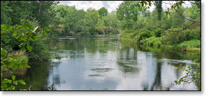
The Tomahawk is an often overlooked gem located in north-central Wisconsin, a few miles south of Minocqua. This an appealing, small-river run where canoers and kayakers will find long stretches of flatwater with occasional riffles and one stretch of whitewater named Halfbreed Rapids, a rocky class II. Most of the river is narrow with a current that varies from slow to medium speeds.
The Tomahawk flows through a varying landscape; from dense forest with occasional high sandy banks, to long stretches of lowland marsh and 'stunted' pine, to open savannah and grassy meadows. Even though large portions of the surrounding land is privately owned, most of the shoreline below Willow Dam is wild and undeveloped. Paddlers will find a quiet and intimate northwoods setting.
A mixed, northern hardwood forest dominates the region. Common hardwoods include: maple, birch, oak, white ash and basswood. Frequent stands of conifers include: hemlock, spruce, tamarack, and red and white pine.
Paddle the river in the early morning or late afternoon hours and you will likely see an abundance of wildlife; migrating waterfowl in the spring and fall; warblers, chickadees and gray jays are common throughout the warm-weather season along with eagle and osprey. White-tailed deer, beaver and otter are often spotted as well.
Camping
Wisconsin State Forest Campgrounds
The scenic Northern-Highlands American Legion State Forest has several beautiful, shady, lakeside family campgrounds close to the Manitowish River. Camping opportunities include: rustic hike-in tent sites, family tent/camper sites, rv sites with electric, and several group sites. The State Forest also features plenty of recreational opportunities, including: hiking, mountain biking, boating, fishing, swimming in sandy-bottomed lakes and miles of paved bicycle paths.
The Clear Lake Camping Area sits close to Minocqua and features a popular, modern family campground at Clear Lake and a rustic family campground at Indian Mounds, a total of 130 sites are reservable.
Also located in the area are three beautiful, rustic family campgrounds: Carrol Lake, Buffalo Lake and Cunard Lake. Many of the sites at these campgrounds are shady and secluded, and all are available on a first-come, first-served basis.
Season
Water levels are dependent upon release from the Willow Reservoir Dam. You may call the Wisconsin Valley Improvement Company at 715.848.2976 or the Woodruff DNR office at 715.356.5211 for information. The river levels are categorized as high, medium, or low. Very high levels can sometimes produce dangerous conditions, medium levels are generally ideal, while low conditions can make navigating the rapids difficult.
River Level Information
Phone Contact for River Info: Wisconsin Valley Improvement Company: 715.848.2976
Phone Contact for River Info: WDNR Woodruff Office: 715.356.5211