

Bois Brule River
(BB4) Highway 13 to Lake Superior Landing, Wisconsin Trail Guide
Trail Facts
| Distance: | 8.2 miles |
| Skill Level: | Novice |
| Whitewater: | Class 1 |
| Approx. Paddle Time: | 4 hours |
| Elevation Drop: | 114 feet |
| Average Gradient: | 13.9 fpm |
Synopsis
Trail Review
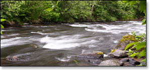
Padlers will find a mostly flatwater run with one class 1 rapids and several long stretches of riffles. You will also see some of the most beautiful river scenery in Wisconsin, especially in the last several miles where the river meanders through tall, steeply sloped hills covered in aspen, birch, maple, pine, spruce and balsam fir. Lake Superior provides a great finale. You will pass by a few cabins along the right bank as you near the lake but they do little to mar the experience.
This section will require a portage at a sea lamprey barrier about 1.8 miles after put-in. The barrier is a river wide dam that was completed in 1984 at the site of a small waterfall. The dam has proven to be very effective in preventing the parasitic sea lamprey from spawning upstream. The portage is well marked and relatively easy.
As with previous sections, this stretch of river is popular amongst anglers, particularly during spring. Wildlife continues to be abundant.
Season
Water levels are usually adequate from spring through fall. Watch out for high levels during snow melt-off in spring.
River Level Information
The river gauge referenced below is roughly 19 miles upstream from this segment. So, while this gauge provides a good indication of the general height of the river, the reading should only be considered as an estimate of the conditions in this reach.
River Gauge Location: Brule, WI
Suggested Minimum Level: 125 cfs / 1.4 feet
USGS Website: 04025500
Phone Contact for River Info: Brule River State Forest - 715.372.4866
Estimated Difficulty at Gauge Flow
| Below 125 cfs |
Paddling not recommended. |
| 125 cfs to 200 cfs |
Low runnable flow. Several riffles and rapids will be bony in this range. |
| 200 cfs to 350 cfs |
Medium runnable flow for novice paddlers. |
| 350 cfs to 600 cfs |
High runnable flow for novice paddlers. |
| 600 cfs to 1000 cfs |
Novice paddlers should avoid the river. |
| Above 1000 cfs |
Rare, high flows. Experienced paddlers only. Deadfall and strainers become quite hazardous when present, may be unavoidable at times! |