

Bois Brule River
(BB1) Stone's Bridge Landing to Bois Brule Landing, Wisconsin Trail Guide
Trail Facts
| Distance: | 11.5 miles |
| Skill Level: | Novice |
| Whitewater: | Class II |
| Approx. Paddle Time: | 4-5 hours |
| Elevation Drop: | 65 feet |
| Average Gradient: | 5.7 fpm |
Synopsis
Trail Review
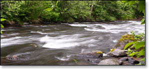
This segment is the most popular trip on the Bois Brule for less experienced canoers and kayakers. The river starts out with a long flatwater stretch through coniferous bog where dense thickets, sedge, tall marsh grasses, and scrub pines dominate the riverbanks. Eventually the marsh gives way to beautiful cedar wetlands where ash, maple, cedar, spruce and fir frequently canopy both banks of the narrow river.
After about 3-1/2 miles, the surrounding landscape subtlety changes into rolling hills and steep banks as the river meanders through quiet pools and gorgeous small lakes. Narrow chutes of low hazard rapids often connect the lakes and pools. Be alert for downed trees in the tight confines of some of the rapids!
As you near the end of this section, the current gradually becomes faster, and rapids become more challenging and numerous. The surrounding hills become increasingly steeper and higher with aspen, birch, and mixed pine covering steep slopes.
Canoe/Kayak Camping
Tthe Bois Brule Campground and Landing is located at the end of this segment. The rustic, family campground is part of the Brule River State Forest and offers 22 shady campsites in a gorgeous pine forest. Five sites are walk-in (tent only), and 17 sites can accommodate tents and/or an RV up to 25-to-90 feet (max length varies). Each site has a picnic table and a fire ring. Amenities include drinking water and vault toilets. There are no electric hookups. Eleven sites are reservable and eleven are available on a first-come, first-served basis.
46.539839, -91.589043
Season
Water levels are usually adequate from spring through fall. Watch out for high levels during snow melt-off in spring.
River Level Information
The river gauge referenced below is located in this segment and should provide an accurate indication of current conditions in this reach.
River Gauge Location: Brule, WI
Suggested Minimum Level: 125 cfs / 1.4 feet
USGS Website: 04025500
Phone Contact for River Info: Brule River State Forest - 715.372.4866
Estimated Difficulty at Gauge Flow
| Below 125 cfs |
Paddling not recommended. |
| 125 cfs to 200 cfs |
Low runnable flow. Several rapids will be bony in this range. Scenic whitewater river trip for novice paddlers. |
| 200 cfs to 350 cfs |
Medium runnable flow for novice paddlers. Little Joe Rapids are class II. Fun whitewater river trip for novice paddlers. |
| 350 cfs to 600 cfs |
High runnable flow for novice paddlers. Some waves may scare or flip less-experienced paddlers. Fast current in constrictions, especially in BB1. |
| 600 cfs to 1000 cfs |
Novice paddlers should avoid the river. BB1 and BB3 are intermediate runs. Fast current in constrictions, especially in BB1. |
| Above 1000 cfs |
Rare, high flows. Experienced paddlers only. Ripping fast current in constrictions. Deadfall and strainers become quite hazardous when present, may be unavoidable at times! |