

Brule River
(B1) Brule River Campground to Highway 139/189 Bridge, Wisconsin Trail Guide
Trail Facts
| Distance: | 14.5 miles |
| Skill Level: | Novice |
| Whitewater: | Class I |
| Approx. Paddle Time: | 6+ hours |
| Elevation Drop: | 115 feet |
| Average Gradient: | 8.4 fpm |
Synopsis
Trail Review
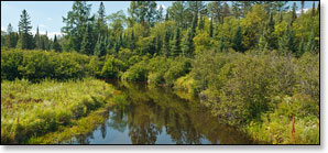
This segment of the Brule River is narrow, marshy and intimate with a large number of small wooded islands. The river flows through a northern lowland forest with spruce, pine, ash, box elder, and maple often shading the riverbanks. Occasionally, the river flows through open marsh and dense thickets. There are several pitches of fun riffles in the final few miles, otherwise this run is mainly flatwater.
There are occasional homes and cottages, but for the most part, this segment is fairly remote and wild. This is a great trip for quiet-water enthusiasts!
Numerous pools between Allen Creek and Highway 139 provide excellent fishing for brook and brown trout, especially around the mouth of Allen Creek.
You will likely see plenty of wildlife, especially in the early morning hours. The Chequamegon-Nicolet National Forest borders the river on the Wisconsin side, while the Michigan DNR owns most of the land on the north bank. There is a sense of remoteness here that is unmatched by most rivers in Wisconsin.
Canoe/Kayak Camping
There is one primitive, riverside canoe/kayak campsite in this segment. The site is located near the Brule River Drive Landing (there are actually two sites here) and is accessible by car, so you can pitch your tent(s) before you paddle. Camping is free and operates on a first-come, first-serve basis. Please limit your stay to one night only!
The Brule River Campground is closed for camping as of 2015. However, the landing is still open.
Season
The river is usually navigable throughout spring, summer and into fall. It can be scrappy in some places during periods of little rainfall in late summer and fall.
River Level Information
River Gauge Location: US Hwy 2 Bridge, MI (north side)
Suggested Minimum Level: 220 cfs / 3.5 feet
USGS Website: USGS Gauge @ Brule, WI