

Brule River
(B3) Forest Road 2150 to Brule River Flowage, Wisconsin Trail Guide
Trail Facts
| Distance: | 14.3 miles |
| Skill Level: | Novice |
| Whitewater: | Class I-II |
| Approx. Paddle Time: | 6+ hours |
| Elevation Drop: | 123 feet |
| Average Gradient: | 8.7 fpm |
Synopsis
Trail Review
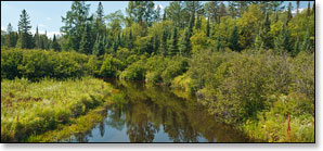
Paddkers will find this to be a very scenic, mainly flatwater run in a quiet and intimate setting. There is one set of rapids that may challenge less experienced paddlers named La Chapelle Rapids, a class 1-2 located a little more than two miles downstream from the US Highway 2 Bridge. A few riffles and easy class 1 rapids are located near McGovern Creek, about five and a half miles from the put-in.
A dense and lush northern lowland forest continues to surround the river, occasionally interrupted by areas of open marsh. Cedar, pine and spruce, along with various hardwoods including stands of aspen and birch canopy the riverbanks. Wildlife is abundant and is most active during the early morning and late afternoon hours. Common species include, white-tailed deer, muskrat, beaver, heron, and numerous species of waterfowl including the common merganser.
Canoe/Kayak Camping
There are no riverside, canoe/kayak campsites in this segment.
Season
The river is usually navigable throughout spring, summer and into fall. It can be scrappy in some places during periods of little rainfall in late summer and fall.
River Level Information
River Gauge Location: US Hwy 2 Bridge, MI (north side)
Suggested Minimum Level: 220 cfs / 3.5 feet
USGS Website: USGS Gauge @ Brule, WI