

Wolf River
(W3) Hollister to Langlade, Wisconsin Trail Guide
Trail Facts
| Distance: | 8.3 miles |
| Skill Level: | Novice |
| Whitewater: | Class II |
| Approx. Paddle Time: | 3 to 4 hours |
| Elevation Drop: | 106 feet |
| Average Gradient: | 12.8 fpm |
Synopsis
Trail Review
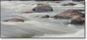
When the river is running at adequate kevels, this is one of the best low-hazard whitewater runs in Wisconsin. Novice whitewater enthusiasts looking for a fun challenge will find several long rapids and boulder gardens with numerous waves, holes, chutes, drops and eddies.
Fortunately, river levels are usually suitable for enjoyable paddling throughout the warm-weather seasons. However, when levels are low the rapids and boulder gardens can be pretty scrappy and will test your maneuvering skills and your patience.
Paddling This Segment
From the Hollister put-in, paddlers will encounter, riffles, boulder gardens, rapids, islands and a few stretches of quiet-water for the first mile or so down through Nine Mile Rapids (class I). Immediately following Nine Mile, the river widens and passes under a tall railroad bridge (now part of the Wolf River Trail System) and forks around a large wooded island. This is a very scenic stretch! More riffles, rapids, boulder gardens and small islands continue for the next two miles.
As its name implies, Oxbow Rapids occurs in a long oxbow about two miles below the railroad bridge. The first and third pitches (both class II) are separated by a bouldery class I pitch around a small island. The third pitch is rather long and provides splashy fun when river levels are medium-to-high.
A brief period of flatwater precedes Cedar Rapids, another long, rocky class II rapids. After a wide shallow pool, the river constricts into Hemlock Rapids (class II), a much shorter rip that peters out into a long set of riffles.
The river is relatively calm for the next two miles until rushing through another long series of challenging class II rapids. Sherry Rapids are first and is the most difficult of this segment. The first long pitch runs through several bends in the right channel around a large wooded island. A brief riffley interlude through a sharp right bend leads into the more difficult second pitch, a 300-yard stretch that provides the biggest waves of this segment when river levels are medium-to-high.
Larzelere Rapids (class II) follows a cluster of islands and is much shorter and easier than Sherry. More islands and bouldery riffles follow downstream.
Locals commonly refer to the stretch between Hollister and Langlade as "Section 2".
Season
The Wolf is fed by a large number of springs and small tributaries which help maintain a consistently navigable flow throughout spring, summer and fall. Occasionally, the river may be too low for an enjoyable paddle during dry spells in summer and fall. However, when a sustained rainfall occurs river levels will rise rapidly and drop slowly - and paddling conditions will be good-to-excellent for an extended period of time.
River Level Information
The river gauge referenced below is located at the end of this segment (Langlade) and should provide an accurate indication of current conditions in this reach. At higher levels, strainers and deadfall become more of a hazard when present.
River Gauge Location: USGS Gauge at Highway 64 Bridge near Langlade, northeast bank.
Suggested Minimum Level: 250 cfs
USGS Gauge Station: 04074950
Suggested River Levels:
| Below 250 cfs |
Paddling not recommended. |
| 250 cfs to 400 cfs |
Low runnable flow. Several of the rapids will be bony rock-gardens in this range. |
| 400 cfs to 600 cfs |
Low runnable flow for an enjoyable run. Good range for novice whitewater paddlers to enjoy this segment. Class I-II rapids and boulder gardens throughout. |
| 600 cfs to 1000 cfs |
Excellent range for novice whitewater enthusiasts looking for a fun challenge. ‘Splashy’ class II waves and numerous drops/holes. |
| 1000 cfs to 1300 cfs |
High runnable flow for novice paddlers. Challenging run for novice whitewater enthusiasts. Several rapids producing class II+ waves. Some rapids ‘washout’. High-speed current in narrow island channels. Scenic whitewater river trip for intermediate paddlers. |
| 1300 cfs to 2000 cfs |
Unusually high flows. Novice paddlers should avoid the river. Pushy waves and sticky holes in several rapids, some are approaching class III. High-speed current through narrow island channels. River banks overflowing at around 1400 cfs. |
| Above 2000 cfs |
Rare, unusually high flows. Paddling not recommended. |