

Wolf River
(W4) Langlade to Markton, Wisconsin Trail Guide
Trail Facts
| Distance: | 9.5 miles |
| Skill Level: | Intermediate |
| Whitewater: | Class II-III |
| Approx. Paddle Time: | 4-5 hours |
| Elevation Drop: | 182 feet |
| Average Gradient: | 19.1 fpm |
Synopsis
Trail Review
The rapids and boulder gardens continue as the river runs through several long stretches of low to medium-hazard rapids that will thrill many whitewater enthusiasts. The rapids are not especially difficult, but when water levels are adequate - which they frequently are - this segment provides many fun drops, holes, waves and eddies.
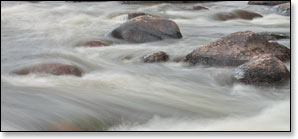
This segment also provides some of the best scenery the river has to offer (outside of the Dells in W5). Most of this nine-mile-plus reach has very little development and features a rocky riverbed and a bouldery shoreline surrounded by a dense hardwood and pine forest; all combine to create a gorgeous wilderness setting.
Paddling This Segment
The first four miles below Langlade features riffles, boulder gardens and several low to medium-hazard rapids with fun drops and wavy chutes. Named rapids in this stretch include, Rocky Rips (class I), Crowle Rapids (class II), Horserace Rapids (class II) and Twenty Day Rapids (class II). About six miles below Langlade is a geologic feature called 'The Ledge', a rocky outcropping that is a popular spot for paddlers to stop and stretch their legs.
The best and most challenging whitewater of this segment occurs a little more than a mile past Herb's Landing where a boulder garden precedes a long, rocky rapid named Boy Scout Rapids (class II-III). The rapids are a solid class 2 in medium flows and a wavy, pushy class 3 when levels are high. Downstream, another stretch of boulders leads into Hanson's Rapids, another long and fun class II with a popular surf spot and numerous waves.
Below County M lies Gilmore's Mistake Rapids (class III), a short and fun drop/hole that is a popular spot to park-n-play.
Whitewater Paddler's Tip
The 3.8-mile stretch between Herb's Landing and the Wild Wolf Inn Landing below County M is called the "Short Section 3" or just "Short 3". This is probably the most-paddled reach of the upper Wolf for whitewater enthusiasts. The short-run features: three popular rapids (Boy Scout, Hanson's and Gilmore's Mistake), no long stretches of flatwater, and a very easy shuttle route. You could run 'Short 3' several times in a single day.
Locals commonly refer to the stretch between Langlade and Markton as "Section 3".
Season
The Wolf is fed by a large number of springs and small tributaries which help maintain a consistently navigable flow throughout spring, summer and fall. Occasionally, the river may be too low for an enjoyable paddle during dry spells in summer and fall. However, when a sustained rainfall occurs river levels will rise rapidly and drop slowly - and paddling conditions will be good-to-excellent for an extended period of time.
River Level Information
The river gauge referenced below is located at the begining of this segment (Langlade) and should provide an accurate indication of current conditions in this reach. At higher levels, strainers and deadfall become more of a hazard when present.
River Gauge Location: USGS Gauge at Highway 64 Bridge near Langlade, northeast bank.
Suggested Minimum Level: 250 cfs
USGS Gauge Station: 04074950
Suggested River Levels:
| Below 250 cfs |
Paddling not recommended. |
| 250 cfs to 400 cfs |
Low runnable flow. Narrow, navigable channels through the rapids which rate from class I to class II. Several of the rapids will be bony rock-gardens. |
| 400 cfs to 600 cfs |
Low runnable flow for an enjoyable run. Class II whitewater run. Several of the rapids still ‘bumpy’ at low end of this range. Several fun holes and surf waves developing. |
| 600 cfs to 950 cfs |
Great range to enjoy this segment. Extended class II+ wave sections in several of the rapids, especially at Boy Scout and Hanson’s. Several fun holes and surf waves. Class III surf waves at Gilmore’s Mistake. Excellent range for whitewater paddlers looking to expand their skill set. |
| 950 cfs to 1200 cfs |
Fun and challenging run for experienced whitewater paddlers. Waves and holes at Boy Scout and Hanson’s Rapids approaching class III. ‘Pushy’ waves at Gilmore’s Mistake, class III+. Powerful hydraulics may scare less-experienced paddlers. |
| 1200 cfs to 1700 cfs |
High runnable flow for intermediate paddlers. Unusually high flows. Several of the rapids are producing ‘pushy’, class III+ waves. High speed flow. Powerful hydraulics in several rapids will overpower less-experienced paddlers. River banks overflowing at around 1400 cfs. |
| 1700 cfs to 2500 cfs |
Rare, unusually high flows. Advanced-level paddlers only! Heavy, ponderous waves and very sticky holes. Paddle with extra caution. |
| Above 2500 cfs |
Rare, unusually high flows. Paddling not recommended. |